
Bến Tre province
Bến Tre province
Kiến Hòa province Trúc Giang province | |
|---|---|
 Bến Tre countryside around Cái Mơn | |
 Seal | |
| Nickname(s): "Coconutland" (Xứ Dừa) | |
 Location of Bến Tre within Vietnam | |
 | |
| Coordinates: 10°10′N 106°30′E / 10.167°N 106.500°E | |
| Country | |
| Region | Mekong Delta |
| Provincial capital | Bến Tre |
| Government | |
| • Body | Bến Tre provincial Party Committee |
| • People's Council Chair | Hồ Thị Hoàng Yến (Communist Party of Vietnam) |
| • People's Committee Chair | Trần Ngọc Tam |
| Area | |
• Total | 2,379.70 km2 (918.81 sq mi) |
| Population (2023) | |
• Total | 1,799,328 |
| • Density | 760/km2 (2,000/sq mi) |
| Demonym | People of Bến Tre |
| Demographics | |
| • Ethnicities | Vietnamese, Khmer, Hoa, Chăm |
| GDP[2] | |
| • Total | VND 41.851 trillion US$ 1.818 billion |
| Time zone | UTC+7 (ICT) |
| Postal code | 86xxx |
| Area codes | 75 (until 16 July 2017) 275 (from 17 June 2017) |
| ISO 3166 code | VN-50 |
| HDI (2020) | (49th) |
| Website | www |
Bến Tre is a province of Vietnam. It is one of the country's southern provinces, and is situated in the Mekong Delta. It is also famous for its coconuts and the Coconut Religion nationwide. Disconnected from the mainland, the province lies mainly on 2 river islands. It has land borders only with Vĩnh Long Province, which occupies the western tip of the southern river island.
Etymology
[edit]The origin of the province’s name is still unclear as it was first inhabited by the Khmer people, though some speculated it may have been called Kompong Russei. Its original name was then later altered by incoming waves of immigration and settlement by ethnic Vietnamese into Bến Tre.[4] In Vietnamese, “Bến Tre” literally means “bamboo port”, which is quite inaccurate considering it is regionally famous for its Coconuts.
History
[edit]Since 1757, the land of Bến Tre belonged to Tân An canton, Định Viễn district, under Long Hồ administrative unit[5]. During the reign of Emperor Minh Mạng, the area was part of Hoằng Trị prefecture (comprising Tân Ninh, Bảo An, and Bảo Hậu districts), under Vĩnh Long province. In 1832, An Hóa islet (now part of Bến Tre province) was included in Kiến Hòa district.
In 1867, the French established Bến Tre as a district (hạt). After several administrative changes, it officially became Bến Tre province in 1900. By 1912, the province was divided into four districts: Ba Tri, Sóc Sải, Mỏ Cày, and Thạnh Phú; Sóc Sải was later renamed Châu Thành in 1927. In 1956, the province was renamed Kiến Hòa and expanded to include nine districts[6].
The revolutionary government continued to refer to it as Bến Tre province. After 1975, there were plans to merge it with other provinces, but it remained a separate province. In 1976, the name was officially changed back to Bến Tre, consisting of one town and seven districts.
In 2009, Mỏ Cày was divided into two districts: Mỏ Cày Bắc (North) and Mỏ Cày Nam (South); Bến Tre town was also upgraded to a city[7][8]. Today, Bến Tre province has nine district-level administrative units, with Bến Tre city classified as a grade-II urban area since 2019.[9]
Administration
[edit]Bến Tre is subdivided into 9 district-level subdivisions. The eight districts are Ba Tri, Bình Đại, Châu Thành,Chợ Lách, Giồng Trôm, Mỏ Cày Bắc, Mỏ Cày Nam, and Thạnh Phú. There is also one provincial city of Bến Tre (capital). They are further subdivided into 7 commune-level towns (or townlets), 147 communes, and 10 wards. To view the list of subdivisions, see List of communes in Bến Tre province.
Geography
[edit]Geographically, Bến Tre is wedged between the two main branches of the Tiền Giang River, which is itself one of the two main distributary of the Mekong. The province's northern boundary is formed by the Tiền Giang's main course, while the province's southern boundary is formed by the Tiền Giang's largest branch (which breaks away from the Tiền Giang just upriver from Bến Tre province). Between the Tiền Giang and its main branch are two smaller branches, passing through the middle of Bến Tre. As a result, this province may be considered having 2 main river islands and has land borders only with Vĩnh Long Province on its western tip.
The entire province is criss-crossed with a network of smaller rivers and canals. The extensive irrigation that this provides makes Bến Tre a major producer of rice, but also means that the area is prone to flooding. The Climate Change Research Institute at Cần Thơ University, in studying the possible consequences of climate change, has predicted that 51% of Bến Tre province can be expected to be flooded if sea levels rise by 1 meter.[10] Bến Tre province is, on average, only 1.25 meters (4 ft 1 in) above sea level.
Transportation
[edit]Construction on the Rạch Miễu Bridge, which links Bến Tre to neighboring Tiền Giang province to its north, was started in 2002. The bridge was finished and opened for traffic on 19 January 2009. Before that time, Bến Tre was only accessible to automobiles via ferry.
Notable people
[edit]- Nguyễn Phương Khánh, Vietnamese beauty pageant titleholder (born 1995 [1994])
Gallery
[edit]
-
 Trung học Phổ thông Chuyên Bến Tre
 -
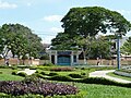 Công viên Trúc Giang
 -
 Kênh Chợ Lách
 -
 Cồn Phụng Hotel
 -
 Tân Thạch Communal House
 -
 Memorial stele
Trương Vĩnh Ký -
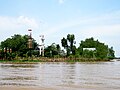 Reserves of Đạo Dừa
at Con Phung -
 Congregation Church
Christ the King -
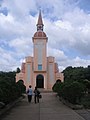 Church of Our Lady
Roman -
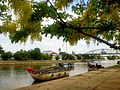
 Tourist boats dock at Con Phung wharf on Tiền River
 -
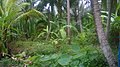 The coconut garden is green thanks to alluvium
 -
 Coconut is a large-scale and popular crop grown in bến Tre


References
[edit]- ^ Biểu số 4.6: Hiện trạng sử dụng đất vùng Đồng Bằng Sông Cửu Long năm 2022 [Table 4.6: Current land use status in the Mekong Delta in 2022] (PDF) (Decision 3048/QĐ-BTNMT) (in Vietnamese). Ministry of Natural Resources and Environment (Vietnam). 18 October 2023. – the data in the report are in hectares, rounded to integers
- ^ "Tình hình kinh tế, xã hội Bến Tre năm 2018". Cổng thông tin điện tử tỉnh Bến Tre. Retrieved 10 May 2020.
- ^ "Human Development Index by province(*) by Cities, provincies and Year". General Statistics Office of Vietnam. Retrieved September 28, 2024.
- ^ Kiernan, Ben (2017). Việt Nam: A history from earliest times to the present. Oxford University Press. p. 10.
- ^ Sách Tài liệu dạy-học chương trình lịch sử địa phương Trung học cơ sở tỉnh Bến tre, Lê Ngọc Bữu(chủ biên), Nhà xuất bản Giáo dục Việt Nam.
- ^ "17/1/1960-Đồng khởi Bến Tre: 62 năm đội quân tóc dài Việt Nam bách chiến bách thắng". Đời sống và Phát triển Online. Retrieved 2025-03-23.
- ^ "Nghị định 08/NĐ-CP điều chỉnh địa giới phường để thành lập xã thuộc huyện Mỏ Cày, Chợ Lách, thị xã Bến Tre Mỏ Cày Bắc thuộc tỉnh Bến Tre mới nhất". THƯ VIỆN PHÁP LUẬT. 2025-01-10. Retrieved 2025-03-23.
- ^ "Nghị quyết 34/NQ-CP thành lập thành phố Bến Tre thuộc tỉnh Bến Tre". THƯ VIỆN PHÁP LUẬT. 2020-09-29. Retrieved 2025-03-23.
- ^ "Quyết định số 174/QĐ-TTg của Thủ tướng Chính phủ: Về việc công nhận thành phố Bến Tre là đô thị loại II trực thuộc tỉnh Bến Tre". vanban.chinhphu.vn (in Vietnamese). Retrieved 2025-03-23.
- ^ "Mekong Delta: more flood and drought" Archived May 5, 2010, at the Wayback Machine. VietnamNet Bridge. 19 March 2009.
External links
[edit]- Bến Tre website (in English)
- Bến Tre website Archived 2014-11-03 at the Wayback Machine (in Vietnamese)
- Bến Tre province profile
- Website Thành phố Bến Tre - Ben Tre City
Places adjacent to Bến Tre province | |
|---|---|
| International | |
|---|---|
| National | |